
Near-surface geophysics
The equipment of the institute includes all common measuring instruments of applied geophysics. These are primarily used in teaching (field courses, final theses) and for various questions on near-surface exploration of the subsurface.
For refraction and reflection seismic investigations, multi-channel seismographs (Summit Compact, 72 channels, DMT) and various seismic sources (drop weights, shear wave source) are available.
For geoelectric measurements and measurements of induced polarisation (IP) effects, the institute has an IRIS Syscal Pro multi-electrode apparatus. In addition, the institute owns Terrameter SAS from ABEM for geoelectrical deep soundings and Lippmann 4-point devices for small-scale investigations.
EM31 (Geonics) and EM34 (Geonics) systems are used for electromagnetic mapping of the electrical conductivity distribution using the two-coil principle.
Proton precession magnetometers (G857, Geometrics), a caesium magnetometer (G858 and G824, Geometrics) and a potassium magnetometer (GSMP-35U, GEM Systems) are used for geomagnetic mapping.
A LaCoste&Romberg gravimeter (G56) is available for gravity measurements.
Ground penetrating radar (GPR) systems, such as the GSSI SIR 3000 and SIR 4000, in combination with GSSI antennas (200 MHz, 400 MHz, 900 MHz) and a digital dual-frequency antenna (300/800 MHz) complete the geophysical measurement systems.

Summit seismographs© Institut fuer Geophysik 
EM31 instrument© Institut fuer Geophysik 
ABEM Terrameter© Institut fuer Geophysik 
Ground-penetrating-radar system from GSSI © Institut fuer Geophysik MT/CSEM receivers
The equipment pool for magnetotelluric (MT) measurements consists of ADU-07e and ADU-08e data loggers (Metronix), MFS-06e and MFS-07e induction coils (Metronix), fluxgate magnetometers (Bartington/Metronix) and non-polarisable electrodes (self-made). In addition, the electronics workshop has developed its own data loggers (EDE) for telluric broadband measurements and for long-period magnetic field measurements with fluxgate magnetometers.
For drone-based semi-airborne EM flights, we use a specially configured ADU-08e (Metronix) in combination with SHFT-02e induction coils (super high-frequency induction coils, Metronix) and a fluxgate magnetometer (Bartington FGS-03e). In addition, we use optically pumped total field magnetometers (Geometrics MagArrow Magnetometer) for semi-airborne EM measurements.

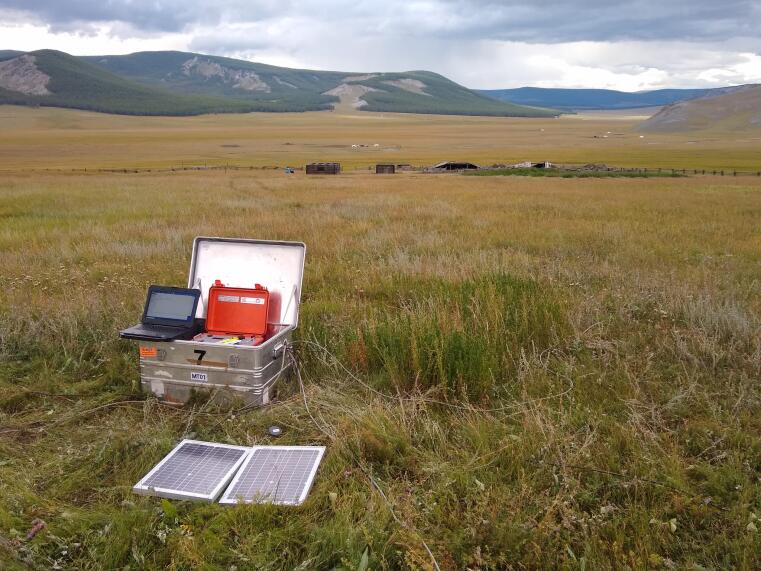
MT station. The data logger (ADU-08e), GPS-antenna, coil and electrode cables as well as solar panels are shown. © Institut fuer Geophysik Drone fleet
The working group owns multicopter UAS (Unmanned Aerial Systems) for geomagnetic and electromagnetic surveys. Our multicopter fleet consists of:
- DJI S1000+ octocopter for geomagnetics with Geometrics MagArrow magnetometer.
- MGT X-825 octocopter (Arealis/MGT) and self-built octocopter (both 25kg MTOW) for electromagnetic surveys with a Metronix data logger (ADU-08e) and a SHFT-02e sensor, as well as Geometrics MagArrow magnetometers.
- Perimeter 8 Hybrdiddrohne from skyfront.

MGT X-825 Octocopter with SHFT-02e sensor© Institut fuer Geophysik 
MGT X-825 Octocopter with MagArrow from Geometrics© Institut fuer Geophysik EM transmitter
For active EM measurements, an alternating electric current is injected into the ground via power sources and the induced electric and/or magnetic field is measured. We use this measurement principle both for purely ground-based measurements (controlled source EM) and in the semi-airborne EM configuration with our drone or helicopter systems.
The 22 kW transmitter TXM-22 (Metronix) as well as the 9kW Zonge transmitter GGT-10B are available as a high-power sources.

Metronix power source© Institut fuer Geophysik Funding

DFG large-scale equipment funding
The working group received funding for the acquisition of an active EM array as part of the "Large-scale research equipment" programme in 2019 (GZ INST 211/864-1 FUGG).
The active EM array consists of the 22 kW high-power transmitter TXM-22 and 5 magnetotelluric broadband receivers ADU-08e with induction coil magnetometers of type MFS06e and MFS07e (Metronix GmbH). The device can be used for active EM exploration measurements (CSEM) and - in combination with drone- or helicopter-towed airborne receivers - in a semi-airborne configuration. The receivers are also suitable for passive magnetotelluric broadband measurements.
Terms of use:
The receivers can generally be borrowed by universities and research institutions for scientific purposes by arrangement. Please contact the head of the working group, Michael Becken, by email: michael.becken@uni-muenster.de
The high-power transmitter can only be used in co-operation projects and with trained personnel from the Applied Geophysics working group at the University of Münster.
BMBF investment funding
As part of the DESMEX projects under FKZ 033R130AN, the working group has received funding for scientific equipment to develop and demonstrate the semi-airborne EM method from the BMBF, co-financed by the EU NextGenerationEU programme. The funded equipment includes multicopter drone systems, a 10 kW high-voltage transmitter (Zonge GGT10B), sensors for recording excited alternating magnetic fields and high-performance computers for inversion calculations.


Other
For surveying tasks, differential GNSS devices (TOPCON and Emlid Reach RS2) and a total station are used (TOPCON). Portable GNSS devices (Garmin GPSMAP 65S) are also available.
For petrophysical investigations, susceptometers are available for field use (SM30 from ZH instruments) and in the laboratory (KLY-3 from AGICO, on loan from the Institute of Mineralogy) as well as a measuring station for permittivity (dielectric constant) with a network analyser (Keysight E5063A).

